Traffic data is essential for municipalities

To shape mobility in a needs-based, efficient, and climate-friendly way, up-to-date traffic data is indispensable. Only through traffic data collection is it clear when, where, and how people move. These data form the basis for targeted infrastructure planning, such as new bike lanes, public transport services, or safe routes to schools. Since traditional surveys are expensive and technically complex, transport planning often relies on assumptions or outdated and incomplete mobility data. This is exactly where we come in. Data on citizens’ actual mobility must be provided in a simple, anonymized, and therefore privacy-compliant way, ensuring precision and timeliness. This makes modern transport planning possible for cities of any size. Additionally, these data can help municipal planners fulfill their obligations under the Mobility Data Regulation or close existing gaps (e.g., in intermodal transport).
Together with our partner Motiontag, we offer municipalities Rethink, a platform that provides mobility planning data via the browser. Without any programming or data analysis skills, cities receive everything they need on the path to more precise transport planning.
“I see in the Klima-Taler data analysis a decisive paradigm shift from transport planning to intermodal mobility planning at the monitoring level: previous local traffic count data can now be supplemented with movement data.”
Daniel Zink, Climate Protection Manager, Königstein im Taunus
Examples of how traffic data is used
The traffic data collection can be used in a variety of ways in your municipality. In the following chapters, you will find some examples of the possibilities and the benefits they can bring to your municipality.
Traffic data helps promote sustainable mobility
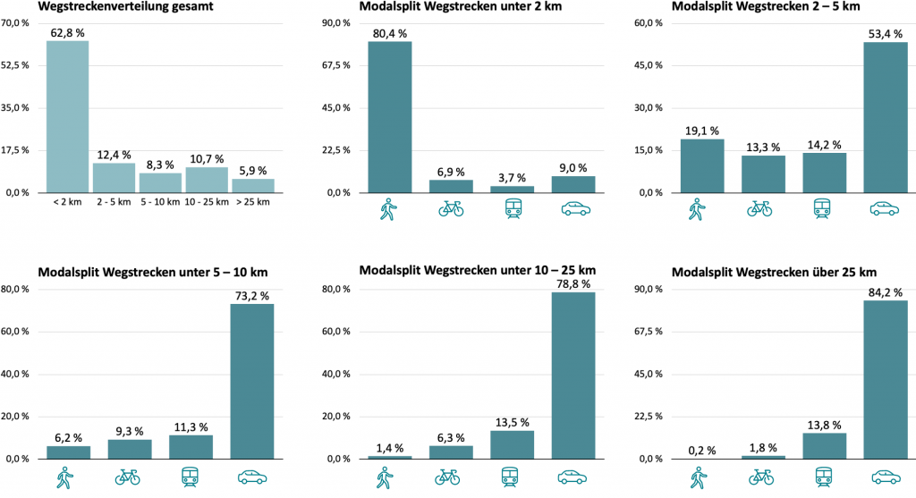
Traffic data collectors answers questions such as how cities can shift short trips under 5 km from cars to bicycles or walking. For mobility planning, a complete modal split by trip length is helpful. This allows the needs of citizens to form the basis of transport planning for municipal administrations. Goals such as reducing inner-city traffic can be justified, addressed, and implemented.
Optimizing public transport schedules based on movement data
Traffic data collection enables municipalities to improve public transport in a targeted way. By analyzing the occupancy of bus and train lines, schedules or service frequencies can be adjusted according to demand. Movement patterns from mobility data also support the planning of new routes and stops. The integration of new mobility options, such as on-demand shuttles or minibuses, can likewise be managed more effectively. Overall, traffic data collection service contributes to a more efficient, flexible, and user-oriented mobility offering.
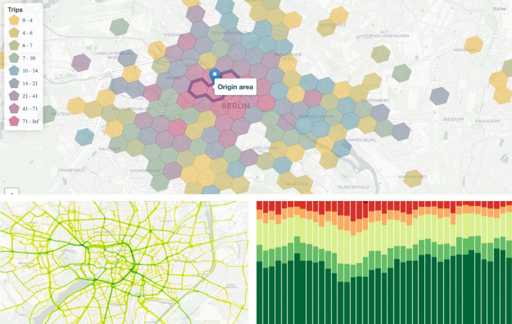
Citizen-focused planning of transport routes and connections
Where is the optimal location for the car-sharing station, the new bus terminal, or the bicycle garage? Those who make such decisions and set the course for a municipality’s climate-friendly mobility concept need mobility data to make the right planning choices. How many people use the station at which times, and how do they continue their journey from there? Which routes are actually used, and are popular shortcuts indicative for new bicycle or pedestrian paths?
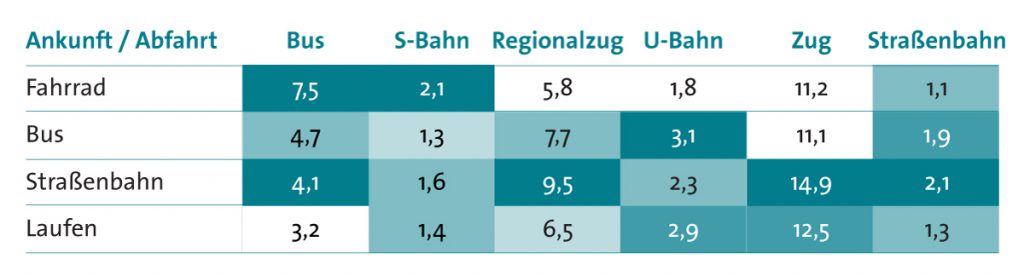
Waiting time for arriving and departing transport modes (in minutes)
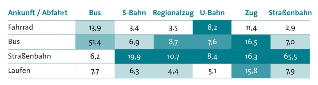
Dwell time by mode of transport, arrival and departure (in minutes)
Traffic data collection leads to greater safety for children and vulnerable groups
Mobility data provides the basis for a targeted analysis of accident hotspots in relation to traffic flow. This allows dangerous intersections or road sections to be identified and mitigated. Especially in the vicinity of schools, the data helps to detect risks early. Based on this, measures such as additional crossing aids or 30 km/h zones can be implemented in a targeted manner. This increases traffic safety, particularly for children and other vulnerable groups.
Planning citizen-focused and climate-friendly mobility with mobility data
ChatGPT:
The Klima-Taler app helps municipalities shape their transport planning in a data-driven, citizen-focused, and climate-friendly way. By automatically tracking everyday routes, it provides precise information on mobility behavior, CO₂ savings, and preferred modes of transport. Traffic data collection enables cities to plan measures such as new bike lanes, safer routes to schools, or additional bicycle parking in a targeted manner, and to evaluate existing infrastructure. A digital dashboard visualizes the insights clearly and supports well-founded decisions—without the need for costly traffic surveys. At the same time, citizens are motivated to actively contribute to climate protection through gamification and rewards.
“The mobility data from the Klima-Taler app is very helpful, as it allows us to evaluate the success of measures. For example, we use the information on which mode of transport (walking, cycling, public transport, car) the community chooses for short trips to assess the impact of measures aimed at upgrading or expanding pedestrian and bicycle paths.”
Dr. Carola Pritzkow, Climate Protection Manager, Nidderau
Managing and making mobility transparent
ChatGPT:
API interfaces enable the integration of data into Smart City dashboards as well as the incorporation of existing digital services.
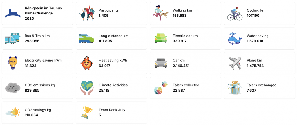
For tracking achieved results, each city receives a dashboard with up to 18 data points—not only in the transport sector but also at the household level. After all, water, heating, and electricity—and thus CO₂—can be saved there as well.
“Any municipality that wonders how it can live up to its role as a model or pioneer in climate protection should engage with the Klima-Taler app, as it enables the participation of all citizens and local businesses under the umbrella of climate protection and municipal administration—and makes it visible to everyone.”
David Reich, Energy Manager, City of Meiningen
At a glance: The key benefits of transport planning with the Klima-Taler app
1. Cost-efficient traffic data collection: The Klima-Taler app automatically records mobility data and provides municipalities with anonymized movement patterns.
2. Evidence-based, citizen-focused transport planning: Cities can see at a glance how and when people move—forming the basis for targeted measures such as bike lanes, safe routes to school, or public transport scheduling.
3. Promotion of sustainable mobility: Using data on modal split and trip lengths, measures to shift travel from cars to bicycles, walking, or public transport can be effectively planned and evaluated.
4. Smart city integration: All data is visualized and presented in a user-friendly way via the Rethink dashboard—ideal for integration into existing smart city strategies.
5. Gamification meets climate protection: Citizens are rewarded with Klima-Taler for sustainable mobility—providing a direct incentive for climate-friendly behavior in everyday life.
Questions? Feel free to reach out to us!
We look forward to meeting you. Let’s explore the possibilities of Klima-Taler data analysis for your municipality together.

Markus Schulz
m.schulz@changers.com
The Klima-Taler app makes it easy to get started with data-driven, climate-friendly, and citizen-focused mobility planning—simple, secure, and effective.
👉 Learn more about the Klima-Taler network for municipalities and districts