Five methods of data analysis for urban planning
Manual counting
Data for urban planning can be collected using simple methods such as manual counting. In this classic survey method, cars, pedestrians, or other road users are counted by hand at specific points and at set times. This provides information on how many people use public spaces or streets at different times of the day. Advantage: The costs are manageable and the data can be targeted. Disadvantage: The data is very limited and only provides snapshots.

Surveys and interviews
Another classic method relies on citizen participation in data-driven urban planning. Qualitative data is collected through surveys or interviews. There are many approaches, ranging from workshops during the planning phase, online surveys on general or specific topics, to individual interviews with representatives of certain target groups. These methods are particularly suitable for gathering subjective opinions. To obtain representative data, however, one should not rely solely on this method, but also include quantitative approaches.
Digital and automated data
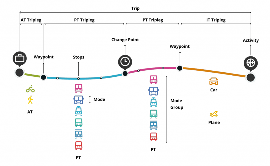
Movement data can be analyzed via GPS, Wi-Fi tracking, or apps. For data-driven urban planning, the Klima-Taler app is a very efficient and cost-effective option. The app was developed jointly by MOTIONTAG, a leading provider of mobility detection technology, and Blacksquared, an app developer focused on climate protection, digitalization, and social change. The Klima-Taler app measures the distances traveled by citizens and distinguishes up to 12 different modes of mobility. What is particularly noteworthy is that walking is also taken into account. Walks make up the largest share of trips under 2 or 5 kilometers, but are often completely overlooked by many measurement methods. At the same time, the app calculates the CO2 balance for environmentally friendly trips compared to car journeys. The Klima-Taler app is therefore particularly suitable for forward-looking, climate-friendly, integrated urban planning.

Sensors and cameras
Sensors and cameras play a central role in for urban planning data. Induction loops and radar sensors built into streets or traffic lights reliably capture traffic volumes in real time. Intelligent traffic cameras with AI technology can additionally distinguish vehicle types and analyze the use of pedestrian and bicycle paths. To monitor environmental quality, noise and fine dust sensors are used. They help identify polluted areas early. The analysis of this data provides an important basis for targeted and sustainable traffic and environmental planning. Disadvantages include the high costs of maintenance and installation, as well as technical limitations. They only provide data from the locations where they are installed, not citywide. This can easily create “blind spots” in data driven urban management.
Use of existing data sources
In future urban planning, existing data sources also play an important role. Official registers and previously collected statistics on population, household sizes, and age composition provide essential baseline information. The same applies to geodata on transport networks, green spaces, noise maps, and zoning plans. These data form the central basis for spatial planning and visualization. However, they are only relevant for future-oriented urban planning beyond assessing the current situation when combined with citizen participation and up-to-date movement data.
Data driven urban planning with the Klima-Taler App
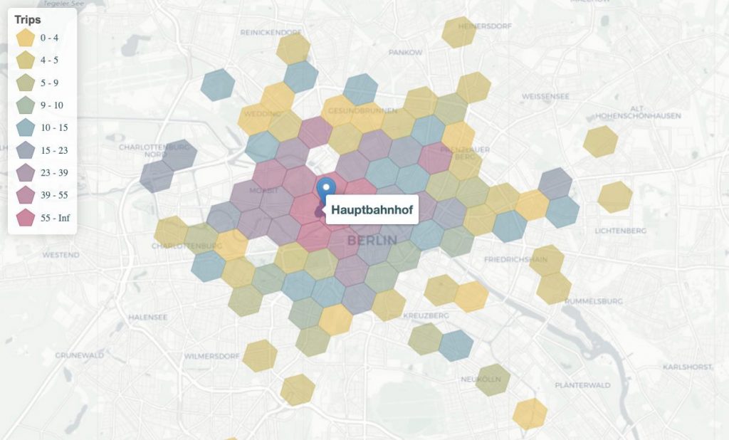
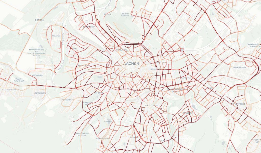
For the data driven urban planning of the future, the city of Aachen has been using the Klima-Taler app, known locally as Aachen.move, since July 2022. The goal of its implementation was to align mobility consistently with the needs of citizens and thereby make an important contribution to the vision of a “Climate-Neutral City 2030.” The insights gained from the analysis of the Aachen mobility app proved to be groundbreaking for integrated urban planning. They provide a detailed understanding of origin-destination dynamics, deep insights into modes of transport for accessing locations, and a comprehensive understanding of usage patterns on newly established bicycle paths. Additionally, this data shed light on travel patterns to and from Aachen’s bus station, helping urban planners optimize transport hubs.
The Klima-Taler app has also been successfully used in Meiningen since 2023. Citizen participation in urban planning data is an important factor there. Climate protection manager David Reich summarizes: “The more users actively participate, the more robust the analysis of data on used bike paths, traffic volumes, parking situations, or rush-hour information becomes. This enables us to plan our green and mobile infrastructure in the long term and pursue urban development with a modern approach.”
Conclusion for data driven city management
The analysis of data is crucial for future-oriented and integrated urban planning. There are various methods for data analysis—from manual counts and archived geodata to digital solutions such as the Klima-Taler app. The Klima-Taler app provides valuable insights for climate-friendly urban planning through anonymized movement and CO2 data. Citizens can use the app to contribute their mobility behavior to urban planning. Many are already successfully using these insights to optimize their infrastructure. The use of such digital tools also strengthens citizen participation and supports sustainable decision-making in integrated urban planning. If you want to know how to use the Klima-Taler app to achieve your municipality’s planning goals, feel free to contact us!
Do you have questions? Get in touch!
We look forward to meeting you. Let’s explore together the possibilities of data-driven urban planning for your municipality.

With the Klima-Taler app, you can take the first step toward data-driven, climate-friendly, and citizen-focused mobility planning – simple, secure, and effective.
👉 Learn more about the Klima-Taler network for municipalities and districts.